LiDAR vs. Photogrammetry: The Ultimate Showdown for 3D Mapping (2024)
Drones have transformed the field of surveying, offering a fast, efficient, and cost-effective way to collect aerial data.
If you're involved in surveying and mapping, you've probably faced the choice between LiDAR and photogrammetry. This isn't just a beginner's dilemma — even experts often debate which is better.
Both technologies provide 3D data, but deciding which one is more suitable can be as challenging as choosing your favorite ice cream flavor.
In this article, we'll explore the differences between LiDAR and photogrammetry so you can make an informed decision about what works best for your project.
Let's dive in.
What is LiDAR and How Does It Work?
LiDAR, short for Light Detection and Ranging, is a key technology in modern remote sensing, used in industries like mining, forestry, agriculture, and construction.
Although LiDAR has been around for decades, recent advancements have made it small enough to fit on drones, opening up new possibilities for data collection and analysis.
At its core, LiDAR is an active remote sensing technology that uses lasers to measure distances between the sensor and objects. A laser pulse is emitted, reflects off objects, and returns to the sensor.
The time it takes for the pulse to return determines the distance with high accuracy. LiDAR systems work with other precision technologies like GNSS and IMUs to create detailed 3D point clouds.
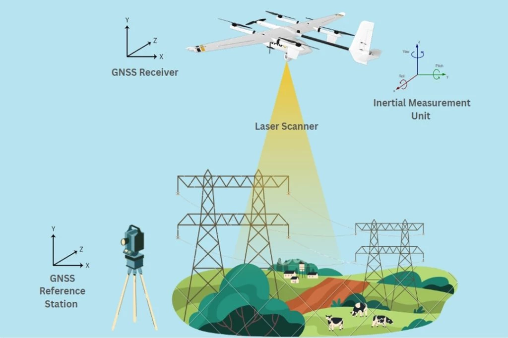
This combination allows LiDAR to capture the shape and location of objects in its environment, providing precise terrain information.
What is Photogrammetry and How Does It Work?
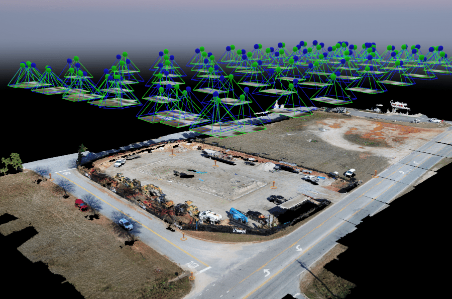
Photogrammetry is an imaging technique that has evolved into a powerful tool across various industries. It creates 3D models by analyzing multiple photographs of an object or scene.
Since the 19th century, it has become essential for many applications. The process begins with capturing numerous images from different angles.
These images are then processed to build a 3D model. Specialized software calculates the position and orientation of each photo in 3D space.
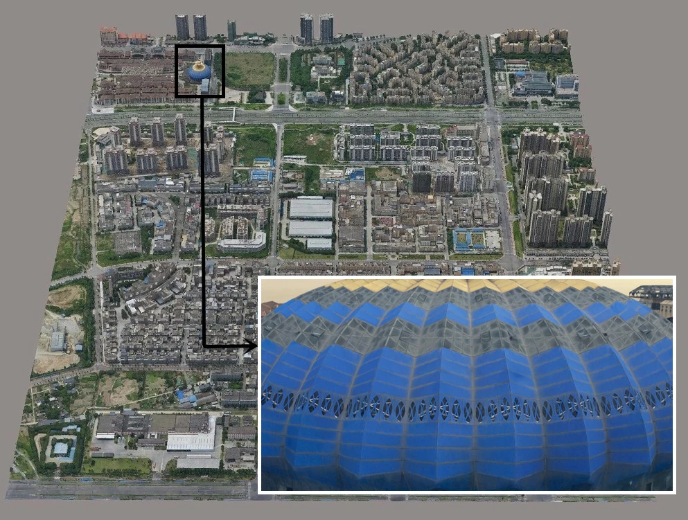
By combining this data, photogrammetry produces accurate 3D models that show the captured environment in detail.
Photogrammetric surveys yield raw images, orthophoto maps, digital surface models (DSMs), and 3D models. Each provides valuable insights into the surveyed area.
LiDAR vs. Photogrammetry: Pros and Cons
In 3D mapping and spatial analysis, LiDAR and photogrammetry are two leading technologies, each with unique strengths and limitations.
Here's a table summarizing the key differences between LiDAR and photogrammetry:
Feature | LiDAR | Photogrammetry |
Accuracy | High | Moderate |
Vegetation penetration | Yes | No |
Light dependence | No | Yes |
Cost | High | Low |
Color information | Limited | High |
Ease of use | Moderate | Easy |
Versatility | Moderate | High |
Processing Time | Fast | Slow |
LiDAR
Pros:
- Precision and Accuracy: LiDAR stands out for its exceptional precision and accuracy in distance measurements. It excels in capturing intricate details with minimal margin for error, making it a preferred choice for applications demanding high accuracy.
- Data Density: LiDAR systems generate dense point clouds, providing a wealth of spatial information. This high data density allows for detailed and intricate mapping, especially in complex terrains or urban environments.
- Penetrates Vegetation: LiDAR can penetrate through canopy cover and thick vegetation, capturing detailed information about the bare ground underneath. This is particularly advantageous in forestry, environmental monitoring, and terrain analysis.
- Nighttime Operation: LiDAR operates effectively during nighttime or low-light conditions. Its ability to emit its light source (laser beams) ensures reliable data acquisition even when traditional optical methods may falter.
Cons:
- High Cost: The operational complexity and need for sophisticated components make LiDAR solutions expensive, often reaching hundreds of thousands of dollars. The traditional bulkiness of LiDAR sensors, coupled with the demand for larger drones to carry heavier payloads, further contributes to the substantial expense.
- Limited Texture and Color Information: While LiDAR excels in distance measurements, it may lack the capability to capture rich textures and color details present in the environment. This limitation can be a drawback in applications where visual aesthetics are essential.
- Expertise for Post-Processing: The post-processing of LiDAR data demands a level of expertise beyond basic training. It often requires specialized knowledge to extract meaningful information from the voluminous point cloud data, potentially complicating the workflow.
Photogrammetry
Pros:
- Cost Effective: Photogrammetry is often more cost-effective than LiDAR, making it an attractive option for projects with budget constraints. The use of commercial drones and cameras contributes to its affordability.
- Rich Textures and Colors: Photogrammetry excels in capturing rich visual details, including textures and colors. This makes it advantageous in applications where a visually realistic representation of the environment is crucial.
- Flexible Workflow: Photogrammetry can adapt to various drone platforms and camera setups. This flexibility allows users to tailor their approach based on the specific requirements of a project, enhancing versatility.
- Easy to Learn: Compared to LiDAR, photogrammetry is generally considered more user-friendly. The learning curve is often less steep, enabling users with varying levels of expertise to generate meaningful 3D models.
Cons:
- Lower Accuracy: Photogrammetric accuracy is influenced by factors such as sensor size, aperture, resolution, and focal length, combined with flight altitude. Achieving absolute accuracy often requires the integration of ground control points or the use of an RTK or PPK-enabled drone.
- Vegetation Occlusion: Dense vegetation can obstruct the view of key features in photogrammetry. Unlike LiDAR, which can penetrate through foliage, photogrammetry may struggle to capture detailed information in areas with significant vegetation cover.
- Require Good Lighting: Adequate lighting conditions are crucial for successful photogrammetry. Poor lighting can result in suboptimal image quality, potentially affecting the accuracy and visual appeal of the final 3D model.
- Processing Time: Photogrammetry, especially when dealing with large datasets, can have longer processing times. This consideration is important in time-sensitive projects where rapid results are imperative.
Ultimately, the best way to choose between LiDAR and photogrammetry is to consider your specific needs and budget. If you need the highest possible accuracy and can afford the cost, LiDAR is the way to go. However, if you're on a budget or need high-quality visual data, photogrammetry may be a better option.
LiDAR vs. Photogrammetry: Which is More Accuracy?
When choosing between LiDAR and photogrammetry for geospatial surveying, the debate inevitably centers around accuracy. Both methods offer reliability when executed meticulously.
To discern their comparative strengths, a closer examination of absolute and relative accuracy is essential.
Absolute (Vertical) Accuracy
Absolute accuracy gauges the precision of an object's or feature's position on the Earth's surface in mapping data. It ensures the alignment between mapped points and their real-world geographic coordinates.
Relative (Vertical) Accuracy
Relative accuracy measures the precision of the positional relationships between different objects or features in mapping data. It assesses the accuracy of the relative positions of points within the same scene, regardless of their absolute position on the Earth's surface.
LiDAR Accuracy
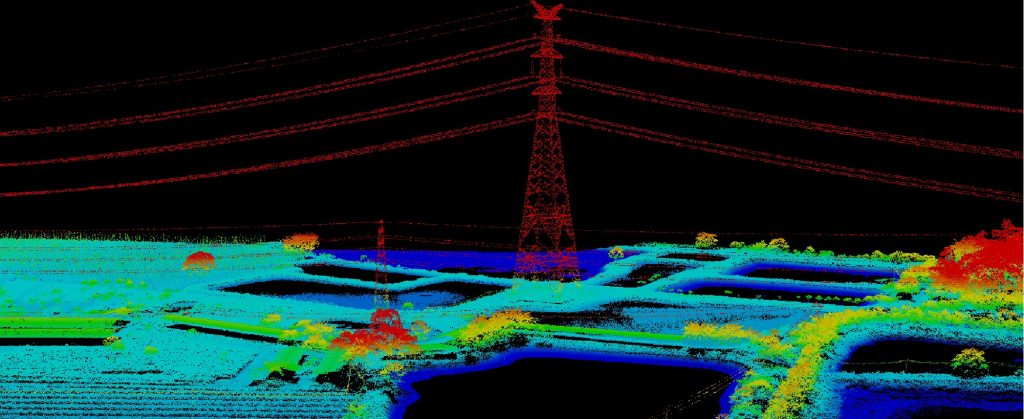
LiDAR boasts high precision, with an anticipated ranging accuracy of 0.5 to 10 millimeters relative to the sensor. Mapping accuracy reaches up to 1 centimeter horizontally (x, y) and 2 centimeters vertically (z).
Point cloud density, the number of points per unit area measured by LiDAR, is key to accuracy, with higher densities yielding more precise maps.
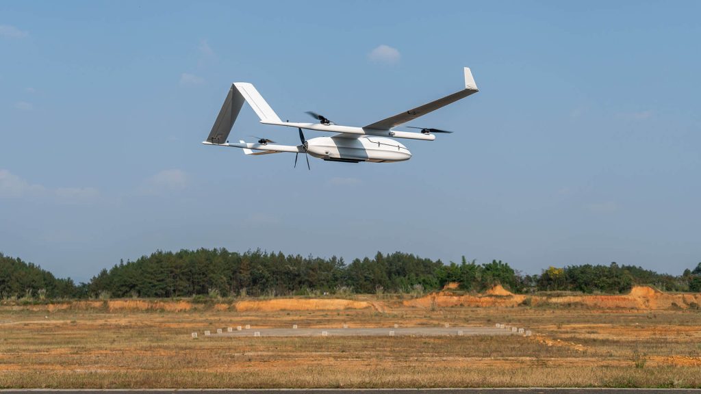
A notable example is the JOUAV CW-25E VTOL UAV equipped with PPK and RTK modules, carrying the JoLiDAR-1500.
This setup generates highly accurate, true-color point clouds with a point density ranging from 50 to 200 points/square meter, providing a typical absolute accuracy of 2-3 cm vertically.
Mounting the JoLiDAR-1500 on a multi-rotor vehicle like the PH-20 further enhances point density and resulting point cloud accuracy.
Flying at low speeds and low altitudes, this configuration achieves point densities between 70 and 500 points/square meter, enabling measurements at 1-centimeter intervals and achieving an absolute horizontal accuracy of about 1 centimeter.
LiDAR's accuracy is attributed to laser pulses directly measuring distances, eliminating errors in manual measurements.
This, coupled with integration with GNSS data, helps provide a high level of vertical accuracy for your digital terrain maps.
LiDAR excels in achieving absolute accuracy, making it an ideal solution for creating realistic models of the bare earth by accounting for elevation and vegetation. With its high data point density, surveyors can generate reliable data sets, and the laser pulse rate plays a crucial role in this.
For instance, a higher pulse rate, such as the JoLiDAR-1500's collection of 1.8 million points per second, allows for more detailed models, reducing the number of flights needed to cover a specific area.
However, it's important to note that LiDAR systems are complex, with various components each contributing to accuracy.
Ranging errors in LiDAR sensors, horizontal and vertical position errors in GNSS, roll, pitch, and heading errors in INS, and other factors need to be considered.
In conclusion, despite complexities and various factors affecting accuracy, LiDAR generally outperforms photogrammetry in producing more detailed and accurate scans. The precision and versatility of LiDAR make it a preferred choice for intricate mapping applications.
Photogrammetry Accuracy
However, this is not to say that photogrammetry is not an accurate measurement solution.
Certain UAV photogrammetry systems can deliver outputs with horizontal (x-y) accuracy as fine as 1 cm (0.4 inches) and elevation (z) accuracy within the same range.
Particularly in areas devoid of dense forest canopy, photogrammetry outshines aerial LiDAR in terms of horizontal accuracy.
Now, achieving such precision isn't a walk in the park. You need specialized payloads armed with the right image sensors and lenses to capture the nitty-gritty details. It's not just a pixel game; it's about finding that sweet spot between sensors and lenses.
Even two cameras flaunting the same megapixel count but with different-sized sensors can dish out different levels of image quality and accuracy.
Optimal accuracy also relies on meticulous mission planning and post-processing. A well-planned mission with adequate image overlap enhances precision and facilitates superior error correction.
High-end UAS, coupled with specialized mission planning and post-processing workflows, play a pivotal role in ensuring the collection of high-quality data that translates into accurate results.
Nevertheless, without the aid of ground control points or RTK- or PPK-enabled UAVs, achieving absolute accuracy in photogrammetry becomes challenging. Shadows, occlusions, and the texture of the surveyed object are additional factors that can impact photogrammetric accuracy.
When all the necessary elements align, photogrammetry excels in terms of relative accuracy.
In contrast, LiDAR stands out by not necessitating ground control points for accurate data acquisition. This stands as a distinct advantage, especially considering the time-consuming nature of setting up GCPs.
LiDAR vs. Photogrammetry Cost
LiDAR tends to be on the pricier side compared to photogrammetry, largely due to the specialized components and advanced technology it requires for drone implementation. The cost variations between the two technologies are noticeable across different facets.
Firstly, the drones themselves: LiDAR-equipped drones come with a higher price tag, ranging from $50,000 to $350,000. This is a reflection of the need for specialized components inherent to LiDAR technology. Conversely, photogrammetry drones are more budget-friendly, falling within the range of $2,000 to $20,000.
Moving on to comprehensive systems, the disparity continues. A high-end photogrammetry system typically costs between $20,000 and $30,000. In contrast, just the sensor for LiDAR systems hits around $100,000. For lightweight drone LiDAR payloads, excluding the drone, the cost falls between $65,000 and $100,000.
Considering drone services, LiDAR services incur higher expenses. The hourly rates for LiDAR drone services range from $300 to $1,000, while photogrammetry-based drone services are comparatively more affordable, averaging between $150 and $500 per hour.
In terms of project-specific costs, photogrammetry emerges as the more cost-effective option. Services covering a 1,100-acre area using photogrammetry range from $1,600 to $1,700, equating to roughly $1.50 per acre. On the other hand, LiDAR data special request areas involve higher costs, starting at $100 for requests up to 50 acres and an additional $2 per acre thereafter, totaling around $4 per acre.
Eagleburgmann Mechanical Seal,Burgmann Mechanical Seal,Mechanical Seal Types,Metal Bellows Seal
Zigong Yibaijie , https://www.oz-yibaijie.com